Learning a Vision-Based Footstep Planner for Hierarchical Walking Control
IEEE-RAS International Conference on Humanoid Robots (Humanoids), 2025
Oral Presentation
Abstract
Bipedal robots demonstrate potential in navigating challenging terrains through dynamic ground contact. However, current frameworks often depend solely on proprioception or use manually designed visual pipelines, which are fragile in real-world settings and complicate real-time footstep planning in unstructured environments. To address this problem, we present a vision-based hierarchical control framework that integrates a reinforcement learning high-level footstep planner, which generates footstep commands based on a local elevation map, with a low-level Operational Space Controller that tracks the generated trajectories. We utilize the Angular Momentum Linear Inverted Pendulum (ALIP) model to construct a low-dimensional state representation to capture an informative encoding of the dynamics while reducing complexity. We evaluate our method across different terrain conditions using the underactuated bipedal robot Cassie and investigate the capabilities and challenges of our approach through simulation and hardware experiments.
System Overview
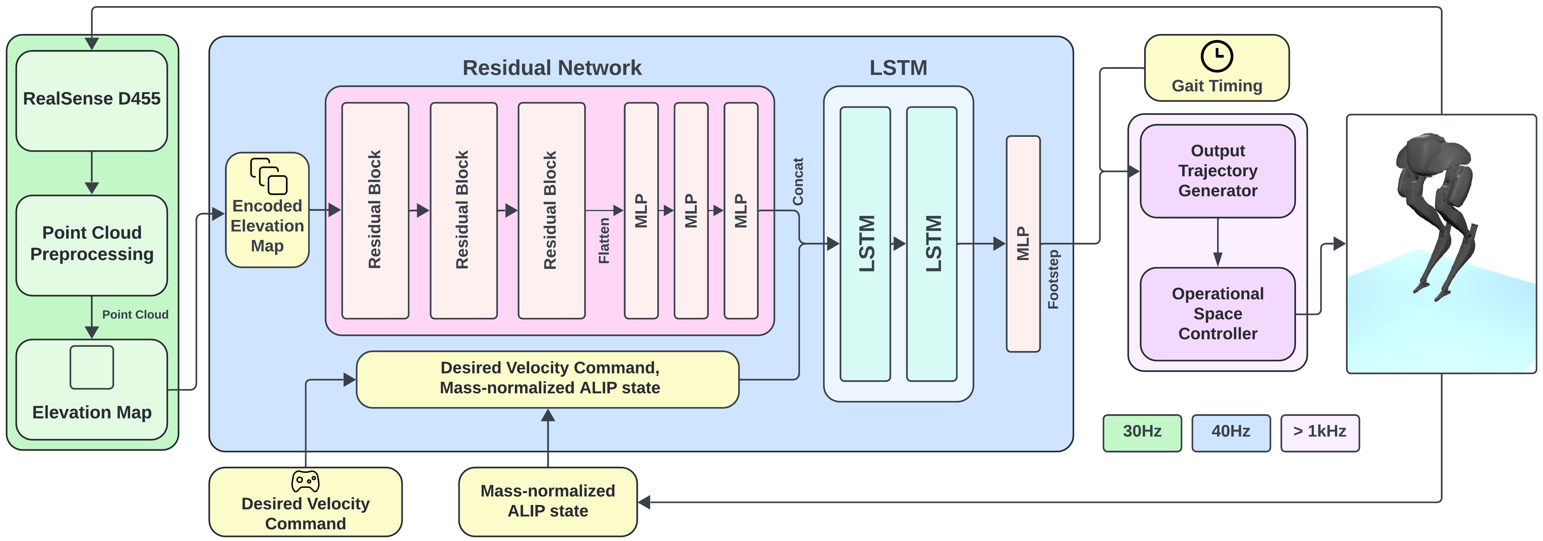
Point clouds acquired by an Intel RealSense D455 are processed to construct a robot-centric elevation map. A residual network extracts terrain features from the encoded map, and a long short-term memory (LSTM) network integrates these features with the desired velocity command and mass-normalized ALIP state to predict three-dimensional footstep locations. The trajectory generator uses these locations to construct swing-foot reference trajectories, which are tracked by the operational space controller (OSC).
Hardware Flat Terrain
Indoor and outdoor walking demonstrations, accompanied by the outdoor terrain-map visualization.
Hardware Stair Terrain
Evaluation on irregular outdoor stairs. The Joint policy, which uses ALIP states and joint positions as inputs, ascends four steps before failure.
Recovery
Selected hardware sequences showing balance recovery and continued stepping after slips and collisions.
Corrupt Vision
Hardware footage and terrain-map visualization with corrupted visual observations. The policy still works with noisy elevation maps and partially observable states.
BibTeX
@inproceedings{kim2025visionfootstep,
  title     = {Learning a Vision-Based Footstep Planner for Hierarchical Walking Control},
  author    = {Kim, Minku and Acosta, Brian and Chaudhari, Pratik and Posa, Michael},
  booktitle = {2025 IEEE-RAS 24th International Conference on Humanoid Robots (Humanoids)},
  year      = {2025},
  pages     = {1--8},
  doi       = {10.1109/Humanoids65713.2025.11203087},
  url       = {https://ieeexplore.ieee.org/document/11203087}
}